Buying a mountain homesite in East Asheville can feel exciting right up until you realize that two lots with the same acreage can have very different building potential. If you are dreaming about views, privacy, or a custom home that fits the land, it helps to know what really matters before you make an offer. This guide walks you through the practical factors that shape a homesite in East Asheville, from slope and access to septic, overlays, and long-term setting. Let’s dive in.
Start With the Landform
In East Asheville, the shape of the land often matters as much as the lot size. Ridges, coves, and valley floors can create very different site conditions over short distances, which means a parcel that looks large on paper may still have only a limited area where a home can realistically sit.
That is especially important in mountain terrain, where aspect, elevation, and slope position affect how a site feels and functions. NC State Extension notes that north and northeast coves are generally more sheltered and moist, while southwest-facing and more exposed sites tend to be drier and more stressed.
For you as a buyer, that can influence everything from sunlight and comfort to landscaping and how the site lives through the seasons. A lot with a dramatic view may not perform the same way as a lot with a more protected setting.
Ridge, Mid-Slope, or Valley-Adjacent?
One of the first questions to ask is where the parcel sits on the mountain. Ridge-top, mid-slope, and valley-adjacent lots each come with different tradeoffs for access, drainage, and building layout.
A ridge lot may offer stronger views and airflow, but it can also face tighter height or disturbance limits in certain overlays. A mid-slope lot may be easier to tuck into the landscape, yet slope and stability become more important. A valley-adjacent parcel may feel more sheltered, though drainage and surface water need close attention.
Use Maps as Clues, Not Final Answers
Buncombe County GIS can be very helpful early in your search. It includes parcel outlines, aerial imagery, surface water, street centerlines, elevations, and contour data, which can help you start reading the land before you visit.
Still, the county is clear that its GIS data should be verified before decisions are made. Buncombe Land Records also states that GIS is not survey grade and should not be used to locate exact lot lines, settle boundary issues, or confirm easements.
That means online maps and listing photos are a starting point, not proof. They may help you spot whether a parcel appears ridge-top or cove-like, but they cannot confirm the exact buildable pad, legal access, or whether a view corridor will remain open.
What To Look For on GIS and Aerials
Before you tour a lot, use maps to look for a few practical signals:
- Contour spacing that suggests steep or moderate slope
- Surface water near the likely homesite
- Whether the lot appears tucked into a cove or exposed on a ridge
- Road approach and possible driveway path
- Signs of neighboring clearing or preserved wooded areas
These clues can help you ask better questions, but they should always be backed up with the right records and professional review.
Pay Close Attention to Landslide and Slope Risk
Asheville identifies landslides as one of its primary hazards, and city resilience materials include East West Asheville, Haw Creek, Town Mountain, Beaverdam, and Chunns Cove among areas with elevated landslide risk for homes and road closures. In a mountain market, that makes terrain risk more than a side issue.
It does not mean every lot in or near these areas is unsuitable. It does mean you should treat slope, drainage, and site history as core parts of your evaluation.
A helpful cross-check is the North Carolina Geological Survey landslide viewer, which the NC Department of Environmental Quality says includes landslide points, outlines, and deposits for western North Carolina. Buncombe County’s hillside-development checklist also requires applicants to show landslide hazard areas, steep-slope and ridge overlays, surface waters, wetlands, floodplain, and slope categories.
When Steep Slope Triggers More Review
Some sites move into a more complex approval path quickly. Buncombe County’s hillside-development checklist states that a global stability analysis is required for homesites on 35 percent or greater slopes, or in areas mapped as high or moderate hazard by the North Carolina Geological Survey.
That matters because a lot that seems workable from the road may need more engineering, more study, or a more limited building approach than you expected. If you are comparing parcels, this is often where the real difference in effort and cost begins to show.
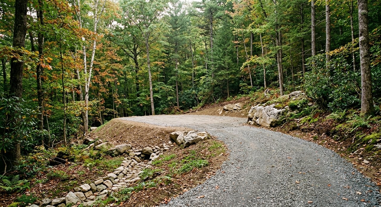
Check Access Before You Fall in Love
Mountain buyers often focus first on views and privacy, but access can shape the entire project. A beautiful homesite loses some appeal if the road approach is complicated, the driveway is too steep, or the legal access is unclear.
Buncombe County’s subdivision ordinance lays out standards for access roads and shared private driveways. For example, a shared private driveway can serve no more than two lots, must be shown on the plat, and must meet width and grade standards. The ordinance also states that these driveways need Fire Marshal approval and must be capable of supporting fire apparatus.
Private subdivision access roads have their own standards too, including a 20-foot deeded and recorded right-of-way, a 16-foot minimum width, and turnouts every 200 feet if the road is less than 20 feet wide.
Access Questions Worth Asking Early
Before you move forward, try to confirm:
- Is access from a public road, access road, or shared private driveway?
- Is the legal access recorded in the deed or plat?
- Does the driveway path appear realistic for the terrain?
- Could grade limits affect where the house can sit?
- Will emergency vehicle access be an issue?
In mountain property, access is part of buildability. It is not just a convenience item.
Understand Septic and Water Early
If the parcel is not served by an available municipal, community, shared, or other water supply, well and septic planning become central to the process. Buncombe Environmental Health states that a building permit will not be issued until an Authorization to Construct is issued for the septic system.
The county also notes that septic permitting or a perc test is one step in the chain of events before construction. Applicants need the parcel PIN and plat, and property lines and house sites should be clearly marked before the site visit.
For buyers, the key takeaway is simple: do not assume a lot will support the home you want just because it is being marketed as buildable. You want to know whether a septic site evaluation has already been completed, where the likely house site is, and how the septic area relates to slope, drainage, and access.
Consider Sun, Exposure, and Daily Livability
A mountain lot is not only about whether you can build. It is also about how the site will feel once you do. Sun exposure, wind, moisture, and seasonal comfort can vary dramatically from one side of the mountain to another.
NC State Extension says east- and west-facing slopes have similar overall sun exposure, but west-facing slopes receive sun during the hottest part of the day. South-facing sites get more sun than north-facing ones, while north and northeast coves are generally more sheltered and moist.
That can affect the placement of outdoor living areas, window orientation, and how much direct light you enjoy. If you want bright morning light, cooler afternoons, or a more sheltered setting, aspect should be part of your decision, not an afterthought.
Review Public Overlays and Private Restrictions
In East Asheville and greater Buncombe County, public rules and private restrictions can both shape what you are allowed to do with a homesite. This is one of the biggest reasons mountain lots that look similar online can turn out to have very different potential.
Buncombe County’s Steep Slope/High Elevation Overlay can require new lots to be at least 1.5 acres, limit building height to 35 feet, and cap disturbance and impervious area. The Protected Ridge Overlay can require 2-acre lots when more than 10 percent of the lot falls in the overlay, limit height to 25 feet within 50 vertical feet of the ridge crest, and add width and disturbance limits.
The City of Asheville also states that steep-slope areas and historic districts have special tree-pruning and removal rules. That matters because tree removal can destabilize slopes and increase runoff, and because some buyers assume they can simply clear for a view.
Private Rules Matter Too
Some limits do not come from zoning at all. Buncombe’s hillside-development rules note that conserved space may be maintained by a mandatory HOA, a perpetual conservation easement, or a governmental body, and that approved site plans and deed restrictions may be recorded.
In practical terms, that means HOA covenants, deed restrictions, recorded plans, or conservation protections may affect clearing, siting, and whether a wooded buffer or view setting is likely to remain in place. If long-term setting is important to you, these documents deserve the same attention as the listing sheet.
A Simple East Asheville Homesite Checklist
When you evaluate a mountain lot, try to answer these questions before making an offer:
- Is the parcel under Asheville city rules, Buncombe County rules, or both?
- Does the landform support a realistic homesite, not just a parcel outline?
- Is there recorded legal access?
- What kind of road or driveway serves the lot?
- Has a septic site evaluation been completed?
- Are property lines and the likely homesite clearly identified?
- Is the parcel in a steep-slope, high-elevation, or protected-ridge overlay?
- Is the area associated with elevated landslide risk?
- Could tree-clearing rules affect the view or building approach?
- Are there HOA rules, deed restrictions, or conservation easements?
If you can answer those questions clearly, you are in a much stronger position to compare lots and move forward with confidence.
Why Local Guidance Matters
Evaluating a mountain homesite in East Asheville takes more than scanning acreage and imagining the view. You are really assessing how landform, access, infrastructure, regulation, and daily livability come together on one piece of property.
That is where local experience can make the process feel much clearer. A team that understands mountain land, community development, and homesite potential can help you look past the marketing language and focus on what supports your goals long term.
If you are exploring land or mountain homes in East Asheville, TFM Carolina can help you evaluate the setting, the practical constraints, and the real opportunity behind each parcel.
FAQs
What should you check first on a mountain homesite in East Asheville?
- Start with the landform, slope, and access. In East Asheville, a lot’s shape and terrain often matter as much as the acreage because they affect where a home can actually be placed.
Can Buncombe County GIS confirm lot lines and buildable area?
- No. Buncombe County says GIS should be verified before decisions are made, and Buncombe Land Records states that GIS is not survey grade and should not be used to locate exact lot lines or resolve boundary questions.
Why does landslide risk matter for East Asheville lots?
- Asheville identifies landslides as a primary hazard, and city materials include East West Asheville among areas with elevated landslide risk for homes and road closures. That makes slope and hazard review an important part of lot evaluation.
What access issues can affect a Buncombe County homesite?
- The type of access matters because shared private driveways and private access roads must meet county standards for width, grade, recording, and in some cases Fire Marshal approval.
When do septic questions become important for a mountain lot in Buncombe County?
- Septic questions matter early. Buncombe Environmental Health says a building permit will not be issued until an Authorization to Construct is issued for the septic system, so you want to understand septic feasibility before moving too far ahead.
Can tree clearing for views be limited in Asheville or Buncombe County?
- Yes. Public overlays, local tree rules, and private restrictions such as HOA covenants or conservation easements can affect whether and how a site may be cleared.
How do slope overlays affect a homesite in Buncombe County?
- Buncombe County overlays can limit lot size, building height, disturbance, and impervious area. On steeper or more sensitive sites, they can meaningfully shape what can be built and where.